Last fall, we finished construction on a wetland restoration project along a creek through our Platte River Prairies. In an earlier post I described some of the issues we had with excess organic matter that mounded up as we filled in the old gravel mine pits. We ended up spreading that sludge out over a portion of the site, and it looks like it may just degrade on its own, so we’re going to let it sit for a season and see what happens.
Regardless of the sludge, the wetland project is one that I’m very happy with, and I’m really looking forward to watching the plant and other ecological communities establish over time. I’m also excited to see the shape of the channels and adjacent wetlands change as groundwater and stream flow levels rise and fall through the years. The project was designed to be dynamic; change is as essential to the future success of the project as any of the wetland construction or wetland seedings we did.
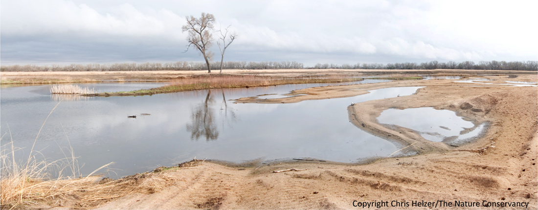
This photo was taken in March, 2012. It's multiple photos stitched together into a panorama. The water was pretty high at the time of the photo, merging together what will be more separate pools and channels when the water levels are lower. The sludge in the distant background of the photo, so the foreground shows mainly bare sand and water - which was planted over the winter with a mixture of locally-harvested wetland seeds.
Because change is such a major emphasis of our project, it fits perfectly into an initiative headed up by Michael Forsberg and Michael Farrell. The Platte River Timelapse Project is designed to merge art and science by using new technology to showcase the dynamic nature of the Platte River and all that it affects. We were fortunate enough to become a partner in the project early on, and Forsberg installed a timelapse camera at the site prior to the beginning of the latest construction phase. That camera takes one photo every hour during daylight hours, and documents the changes that take place in front of it. The plan is to leave it in place for many years. Even better, we hope to have two more cameras up and running within the next several weeks, greatly increasing our ability to tell the story of this wetland.
Here is the timelapse of our project through the end of March. If your internet service is like mine, the video may be a little jerky the first time through, but if you just click play again and rewatch it after the first time, it runs much more smoothly. The whole video is only 52 seconds long. You can see the construction equipment at work as they reshape the topography, and then watch the wildlife response – especially during the spring bird migration. As the season progresses, the video will be updated with new footage, and we’ll be able to watch the establishment of the vegetation and the rise and fall of water levels.
There are lots of other timelapse videos you can watch on the same website. As a starting point, I strongly recommend this terrific series from the top of a tower at Audubon’s Rowe Sanctuary, showing the Platte River, sandbars, and lots of sandhill cranes. During the first minute or so, the movements of the roosting sandhill cranes are fascinating. Starting at about 1:30, though, the story becomes the waves of sediment rolling down the channel – very clearly demonstrating the primary role of rivers… to move sediment.
Stay tuned! I’ll post more video of our wetland project when it becomes available. In the meantime, they’ll continue to update all of the other footage at the Platte River Timelapse site too, so you can return now and then to see what’s changing.


